
Loading, please wait...
Details
LOT 1985
General Books - Anderson - The Book of British Topography
1881 A.D.
6 7/8 x 9 3/4 in. (1.17 kg, 24.5 x 17.5 cm).
John P. Anderson - The Book of British Topography - W Satchell & Co, London, 1881 - hardback, cloth covers, gld titling to spine - 472 pp; spine loose, boards partly detached. [No Reserve]
Provenance
Property of a Kent, UK, collector.
CONDITIONVETTING:
TimeLine Auctions follows a vetting process to ensure the authenticity and legality of all items, reinforcing our commitment to integrity and responsible trading. Each antiquity, antique, and coin lot undergoes thorough examination by a vetting committee of at least ten external specialists, professional trade association members, scientists, and archaeologists: Our Vetting Process
AUCTIONS:
TimeLine is a leading auction house specialising in antiquities, ancient art, collectables, natural history, coins, medals, and books. Our auctions offer museums, collectors, historians, and enthusiasts the opportunity to acquire unique and historically significant pieces.
LOT 1985
General Books - Anderson - The Book of British Topography
Sold for (Inc. bp): £3
RELATED LOTS
-
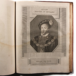
General Books - Rapin's History of England Plate Atlas in Royal Binding
Published 1813-1816 A.D.Sold for (Inc. bp): £111
An atlas volume of forty steel-engraved plates of the Kings and Queens of England from Egbert to the Prince Regent, from the monumental The History of England by Thoyras [Pau] Rapin, with laid down title page stating 'Published by J & J Cundee, Ivy Lane, Paternoster Row, London'; the plates generally water stained to lower parts and with some light foxing; the original binding of superb quality red morocco bearing the impressed and gilded framed royal arms with repeated emblems (leek, thistle, shamrock and rose) around for the United Kingdom with ornamental corners; rebound at some time with later spine and board edges re-covered. Binding repaired but boards fine (lightly soiled), plates water stained. 786 grams, 32 x 25 cm
Property of a Kent, UK, collector. -
.jpg)
General Books - Boyle - London: A Cartographic History 1746-1950, 200 Years of Folding Maps
2002 A.D.Sold for (Inc. bp): £20
Lucinda Boyle - London: A Cartographic History 174 6-1950, 200 Years of Folding Maps - Countrywide, Wycombe, 2002 - hardback with dustwrapper, 161 pp, colour maps. 1.2 kg, 32 x 23 cm
Property of a Kent, UK, collector. -
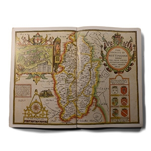
General Books - Nicolson - The Counties of Britain - A Tudor Atlas by John Speed
1988 A.D.Sold for (Inc. bp): £33
Nigel Nicolson - The Counties of Britain - A Tudor Atlas by John Speed - Pavilion Books, London, 1995 - card covers, 288 pp, reproduction maps. 1.22 kg, 30.5 x 20 cm
Property of a Kent, UK, collector.
